
Thank you for supporting this site ❤️
Make a donation
Make a donation
Gear up for your next adventure:
As an Amazon Associate, this site earns from qualifying purchases at no extra cost to you.
Proença-a-Nova topographic map
Click on the map to display elevation.
Thank you for supporting this site ❤️
Make a donation
Make a donation
Gear up for your next adventure:
As an Amazon Associate, this site earns from qualifying purchases at no extra cost to you.
About this map
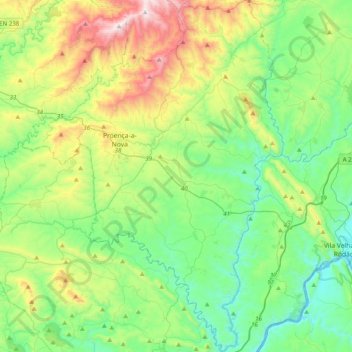
Name: Proença-a-Nova topographic map, elevation, terrain.
Location: Proença-a-Nova, Castelo Branco, Portugal (39.56578 -8.03575 39.87061 -7.73967)
Average elevation: 1,184 ft
Minimum elevation: 226 ft
Maximum elevation: 3,550 ft
Thank you for supporting this site ❤️
Make a donation
Make a donation
Gear up for your next adventure:
As an Amazon Associate, this site earns from qualifying purchases at no extra cost to you.