Geolocate

Cemandi topographic map

Click on the map to display elevation.

About this map
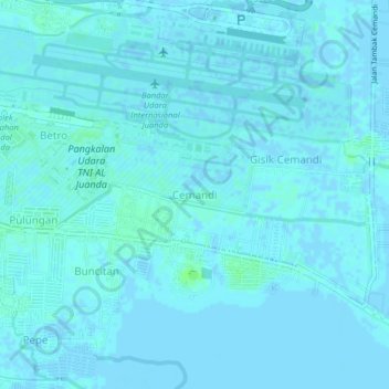
Name: Cemandi topographic map, elevation, terrain.

Location: Cemandi, Sedati, Sidoarjo, East Java, 61253, Indonesia (-7.41149 112.76944 -7.37149 112.80944)

Average elevation: 3 ft

Minimum elevation: -13 ft

Maximum elevation: 23 ft

Other topographic maps

Click on a map to view its topography, its elevation and its terrain.

Jabon

Indonesia > East Java > Sidoarjo

Average elevation: 10 ft

Candi

Indonesia > East Java > Sidoarjo

Average elevation: 10 ft

Tulangan

Indonesia > East Java > Sidoarjo

Average elevation: 26 ft

Sukodono

Indonesia > East Java > Sidoarjo

Average elevation: 26 ft

Krembung

Indonesia > East Java > Sidoarjo

Average elevation: 33 ft

Prambon

Indonesia > East Java > Sidoarjo

Average elevation: 43 ft

Tanggulangin

Indonesia > East Java > Sidoarjo

Average elevation: 10 ft

Gear up for your next adventure:

🛰️Satellite Messengers - Emergency SOS and two-way messaging for off-grid adventures
☕Camping Coffee Makers - Enjoy premium coffee at the summit or campsite
🏔️Mountain Trail Maps - High‑detail maps for popular peaks
💧Water Purification System - Clean water on the trail with reliable purifiers
📦Dry Bags Set - Waterproof storage for electronics and clothes

As an Amazon Associate, this site earns from qualifying purchases at no extra cost to you.