
Thank you for supporting this site ❤️
Make a donation
Make a donation
Gear up for your next adventure:
As an Amazon Associate, this site earns from qualifying purchases at no extra cost to you.
Choccayhua topographic map
Click on the map to display elevation.
Thank you for supporting this site ❤️
Make a donation
Make a donation
Gear up for your next adventure:
As an Amazon Associate, this site earns from qualifying purchases at no extra cost to you.
About this map
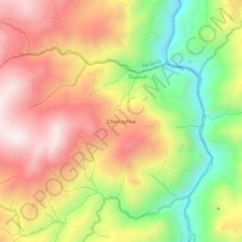
Name: Choccayhua topographic map, elevation, terrain.
Location: Choccayhua, Quehue, Canas, Cusco, Perú (-14.32904 -71.53569 -14.28904 -71.49569)
Average elevation: 12,828 ft
Minimum elevation: 11,473 ft
Maximum elevation: 14,022 ft
Thank you for supporting this site ❤️
Make a donation
Make a donation
Gear up for your next adventure:
As an Amazon Associate, this site earns from qualifying purchases at no extra cost to you.