
Make a donation
Gear up for your next adventure:
As an Amazon Associate, this site earns from qualifying purchases at no extra cost to you.
Vaterstetten topographic map
Click on the map to display elevation.
Make a donation
Gear up for your next adventure:
As an Amazon Associate, this site earns from qualifying purchases at no extra cost to you.
About this map
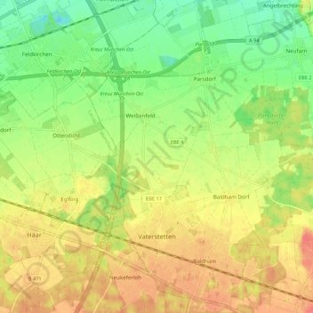
Name: Vaterstetten topographic map, elevation, terrain.
Location: Vaterstetten, Landkreis Ebersberg, Bavaria, Germany (48.08825 11.74770 48.15981 11.84503)
Average elevation: 1,759 ft
Minimum elevation: 1,670 ft
Maximum elevation: 1,841 ft
Make a donation
Gear up for your next adventure:
As an Amazon Associate, this site earns from qualifying purchases at no extra cost to you.
Other topographic maps
Click on a map to view its topography, its elevation and its terrain.
Make a donation
Gear up for your next adventure:
As an Amazon Associate, this site earns from qualifying purchases at no extra cost to you.
Hesselfurt
Germany > Bavaria > Landkreis Ebersberg > Grafing > Grafing-Bahnhof
Average elevation: 1,775 ft