Geolocate

Spin topographic map

Interactive map

Click on the map to display elevation.

About this map

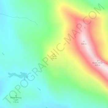
Name: Spin topographic map, elevation, terrain.

Location: Spin, Western Isles, Scotland, HS8 5SN, United Kingdom (57.26038 -7.31508 57.26048 -7.31498)

Average elevation: 791 ft

Minimum elevation: 161 ft

Maximum elevation: 1,975 ft

Other topographic maps

Click on a map to view its topography, its elevation and its terrain.

Reef

United Kingdom > Scotland > Western Isles

Reef, Western Isles, Scotland, HS2 9HU, United Kingdom

Average elevation: 59 ft

Mingulay

United Kingdom > Scotland > Western Isles

Mingulay, Western Isles, Scotland, United Kingdom

Average elevation: 141 ft

St Kilda

United Kingdom > Scotland > Western Isles

St Kilda, Western Isles, Scotland, United Kingdom

Average elevation: 36 ft

Balranald

United Kingdom > Scotland > Western Isles > Balranald

Balranald, Western Isles, Scotland, HS6 5DW, United Kingdom

Average elevation: 43 ft