Geolocate

La Union topographic map

Click on the map to display elevation.

About this map

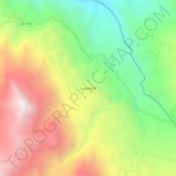
Name: La Union topographic map, elevation, terrain.

Location: La Union, Usquil, Otuzco, La Libertad, Perú (-7.87718 -78.35642 -7.83718 -78.31642)

Average elevation: 9,396 ft

Minimum elevation: 7,096 ft

Maximum elevation: 12,057 ft

Gear up for your next adventure:

🥾Hiking Shoes - Durable and comfortable shoes for trail hiking
🧭GPS Watch Accessories - Bands and chargers for GPS watches
🕶️Glacier Sunglasses - Side shields to protect eyes from high-altitude snow glare
🪶LED Camping Lantern - Bright lantern for camp lighting
🧷Carabiner Set - Durable clips for gear attachment

As an Amazon Associate, this site earns from qualifying purchases at no extra cost to you.