
Make a donation
Gear up for your next adventure:
As an Amazon Associate, this site earns from qualifying purchases at no extra cost to you.
Camini topographic map
Click on the map to display elevation.
Make a donation
Gear up for your next adventure:
As an Amazon Associate, this site earns from qualifying purchases at no extra cost to you.
About this map
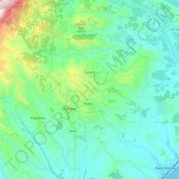
Name: Camini topographic map, elevation, terrain.
Location: Camini, Reggio Calabria, Calabria, Italia (38.40331 16.46680 38.44580 16.56835)
Average elevation: 679 ft
Minimum elevation: 0 ft
Maximum elevation: 3,009 ft
Make a donation
Gear up for your next adventure:
As an Amazon Associate, this site earns from qualifying purchases at no extra cost to you.
Other topographic maps
Click on a map to view its topography, its elevation and its terrain.
Pentidattilo
Italia > Calabria > Reggio Calabria > Melito di Porto Salvo
Quello che era l'antico paese, a 320 metri di altitudine, è stato definitivamente abbandonato nel 1971, dopo che, tre anni prima, era stato dichiarato inabitabile: la popolazione era infatti migrata leggermente più a valle formando un nuovo piccolo centro dal quale si poteva ammirare il vecchio paese fantasma.
Average elevation: 843 ft
Make a donation
Gear up for your next adventure:
As an Amazon Associate, this site earns from qualifying purchases at no extra cost to you.
Villaggio Zomaro
Italia > Calabria > Reggio Calabria > Cittanova > Villaggio Zomaro
Average elevation: 2,779 ft