
Make a donation
Gear up for your next adventure:
As an Amazon Associate, this site earns from qualifying purchases at no extra cost to you.
Breesport topographic map
Click on the map to display elevation.
Make a donation
Gear up for your next adventure:
As an Amazon Associate, this site earns from qualifying purchases at no extra cost to you.
Breesport
Breesport is located on the eastern side of the town of Horseheads at 42°10′24″N 076°44′02″W / 42.17333°N 76.73389°W / 42.17333; -76.73389 (42.173408, -76.733841). Its elevation is 1,099 feet (335 m). Its eastern edge is the border between Horseheads and the town of Erin. New York State Route 223 passes through the center of Breesport, leading west 3 miles (5 km) to NY-13 near the village of Horseheads and east 3.5 miles (5.6 km) to Erin.
Make a donation
Gear up for your next adventure:
As an Amazon Associate, this site earns from qualifying purchases at no extra cost to you.
About this map
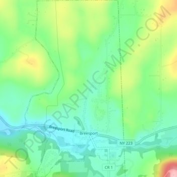
Name: Breesport topographic map, elevation, terrain.
Average elevation: 1,227 ft
Minimum elevation: 1,056 ft
Maximum elevation: 1,565 ft
Chemung County trails, hiking, mountain biking, running and outdoor activities
Make a donation
Gear up for your next adventure:
As an Amazon Associate, this site earns from qualifying purchases at no extra cost to you.
Other topographic maps
Click on a map to view its topography, its elevation and its terrain.
Orchard Knoll
United States > New York > Chemung County > Town of Horseheads
Average elevation: 1,102 ft