Geolocate

Middlefield topographic map

Click on the map to display elevation.

About this map

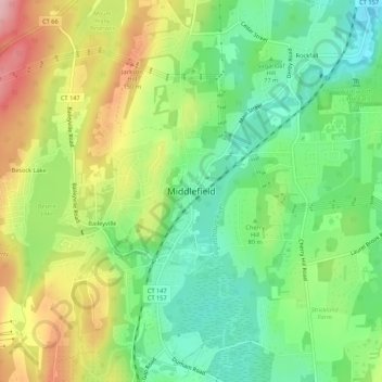
Name: Middlefield topographic map, elevation, terrain.

Location: Middlefield, Middlesex County, Connecticut, 06455, USA (41.49652 -72.73208 41.53652 -72.69208)

Average elevation: 292 ft

Minimum elevation: 59 ft

Maximum elevation: 633 ft

Gear up for your next adventure:

🪶Survival Guide Book - Expert advice for emergency preparedness
🖼️Topo Map Wall Art - Decorative topographic prints of famous peaks and regions
📚Navigation Handbooks - Master the art of reading topographic maps and using a compass
🧭Orienteering Set - Complete compass and map reading kit
🧭GPS Watch Accessories - Bands and chargers for GPS watches

As an Amazon Associate, this site earns from qualifying purchases at no extra cost to you.