Geolocate

Jacksonville topographic map

Click on the map to display elevation.

About this map

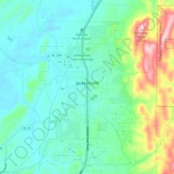
Name: Jacksonville topographic map, elevation, terrain.

Location: Jacksonville, Calhoun County, Alabama, 36265, United States (33.77400 -85.78659 33.84968 -85.70733)

Average elevation: 823 ft

Minimum elevation: 564 ft

Maximum elevation: 1,654 ft

Calhoun County trails, hiking, mountain biking, running and outdoor activities

Other topographic maps

Click on a map to view its topography, its elevation and its terrain.

Coldwater

United States > Alabama > Calhoun County > Oxford

Average elevation: 633 ft

Golden Springs

United States > Alabama > Calhoun County > Anniston

Average elevation: 948 ft

Bonny Brook

United States > Alabama > Calhoun County > Jacksonville

Average elevation: 781 ft

McKibben

United States > Alabama > Calhoun County > Oxford

Average elevation: 794 ft

Alexandria

United States > Alabama > Calhoun County

Average elevation: 617 ft

Blue Mountain

United States > Alabama > Calhoun County > Anniston

Average elevation: 968 ft

Gear up for your next adventure:

🎒Hydration Pack - Hands‑free water reservoir for long hikes
🛌Ultralight Sleeping Bags - Compact down bags for cold nights in the wilderness
🥘Titanium Cookware - Durable, featherlight pots and pans for backpacking
🌐World Map Poster - Decorative world maps with topographic info
🪶Camp Gear Gift Set - Perfect gift bundle for outdoor fans

As an Amazon Associate, this site earns from qualifying purchases at no extra cost to you.