
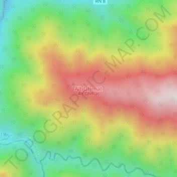
Aït Ghmat topographic map
Interactive map
Click on the map to display elevation.
About this map
Name: Aït Ghmat topographic map, elevation, terrain.
Location: Aït Ghmat, Souhane, Daïra Larbâa, Blida, Algérie (36.50405 3.20150 36.50415 3.20160)
Average elevation: 1,781 ft
Minimum elevation: 712 ft
Maximum elevation: 3,015 ft
Other topographic maps
Click on a map to view its topography, its elevation and its terrain.
Sahraoui
Algérie > Blida > Daïra Larbâa > Larbaa
Sahraoui, Larbaa, Daïra Larbâa, Blida, 09300, Algérie
Average elevation: 295 ft
Belaouadi
Algérie > Blida > Daïra Larbâa > Larbaa
Belaouadi, Larbaa, Daïra Larbâa, Blida, 16189, Algérie
Average elevation: 210 ft
Larbaa
Algérie > Blida > Daïra Larbâa
Larbaa, Daïra Larbâa, Blida, 09300, Algérie
Average elevation: 656 ft