Geolocate

Juneau topographic map

Click on the map to display elevation.

About this map

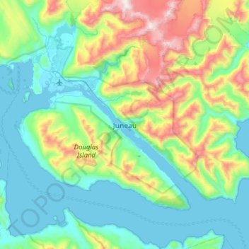
Name: Juneau topographic map, elevation, terrain.

Location: Juneau, Alaska, 99802, United States (58.14195 -134.57973 58.46195 -134.25973)

Average elevation: 1,227 ft

Minimum elevation: -13 ft

Maximum elevation: 5,446 ft

Alaska trails, hiking, mountain biking, running and outdoor activities

Other topographic maps

Click on a map to view its topography, its elevation and its terrain.

Mendenhall Glacier

United States > Alaska > Juneau

Average elevation: 1,178 ft

Lemon Creek

United States > Alaska > Juneau

Average elevation: 1,414 ft

Lena Beach

United States > Alaska > Juneau > Lena Beach

Average elevation: 338 ft

West Juneau

United States > Alaska > Juneau

Average elevation: 361 ft

Gear up for your next adventure:

🔭Stargazing Telescopes - Perfect for camping in low-light pollution areas shown on maps
🏕️Family Camping Gear - Essentials for group camping trips
🪑Portable Camp Table - Compact table for campsite meals
🌧️Backpack Rain Cover - Keep gear dry in wet weather
📦Dry Bags Set - Waterproof storage for electronics and clothes

As an Amazon Associate, this site earns from qualifying purchases at no extra cost to you.