
Mazandú topographic map
Interactive map
Click on the map to display elevation.
About this map
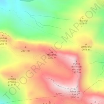
Name: Mazandú topographic map, elevation, terrain.
Location: Mazandú, Ansó, Jacétanie, Huesca, Aragon, Espagne (42.83404 -0.76149 42.83414 -0.76139)
Average elevation: 6,358 ft
Minimum elevation: 4,816 ft
Maximum elevation: 7,769 ft
Other topographic maps
Click on a map to view its topography, its elevation and its terrain.
Pic d'Ansabère
Pic d'Ansabère, Ansó, La Jacetania, Huesca, Aragon, Espagne
Average elevation: 6,401 ft
Lac d'Estaëns
Lac d'Estaëns, GR11 - Senda de Camille, Ansó, La Jacetania, Huesca, Aragon, Espagne
Average elevation: 5,978 ft