Geolocate

Siparia topographic map

Click on the map to display elevation.

About this map

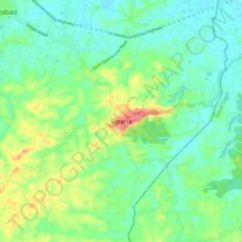
Name: Siparia topographic map, elevation, terrain.

Location: Siparia, Trinidad and Tobago (10.10407 -61.54736 10.18407 -61.46736)

Average elevation: 75 ft

Minimum elevation: 0 ft

Maximum elevation: 243 ft

Other topographic maps

Click on a map to view its topography, its elevation and its terrain.

Vessigny Beach

Trinidad and Tobago > Siparia > Vessigny

Average elevation: 39 ft

Gear up for your next adventure:

🧯Emergency Survival Kit - All‑in‑one survival essentials for the backcountry
🎒Day Hiking Backpack - Lightweight backpack perfect for day trips and outdoor adventures
🧭Map Reading Tools - Tools and kits for map navigation
🛠️Outdoor Gear Repair Kit - Essential tools to fix gear on the trail
🏕️Tent Footprint - Protect your tent base from wear

As an Amazon Associate, this site earns from qualifying purchases at no extra cost to you.