
Vals topographic map
Interactive map
Click on the map to display elevation.
About this map
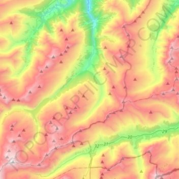
Name: Vals topographic map, elevation, terrain.
Location: Vals, Surselva, Grisons, 7132, Switzerland (46.49395 9.01662 46.68213 9.24341)
Average elevation: 7,142 ft
Minimum elevation: 3,179 ft
Maximum elevation: 10,932 ft
Before 2017, the municipality was located in the Lugnez sub-district of the Surselva district, after 2017 it was part of the Surselva Region. It consists of the village of Vals at an elevation of 1,252 m (4,108 ft) and the hamlets of Leis at an elevation of 1,526 m (5,007 ft)). The highest point of the municipality is reached on Rheinwaldhorn on 3,402 m (11,161 ft).
Other topographic maps
Click on a map to view its topography, its elevation and its terrain.
Breil/Brigels
Switzerland > Grisons > Surselva
Breil/Brigels, Surselva, Grisons, Switzerland
Average elevation: 6,184 ft
Lake Toma
Switzerland > Grisons > Surselva > Tujetsch
Lake Toma, Tujetsch, Surselva, Grisons, Switzerland
Average elevation: 7,841 ft
Medel (Lucmagn)
Switzerland > Grisons > Surselva
Medel (Lucmagn), Surselva, Grisons, Switzerland
Average elevation: 6,890 ft
Soladüra
Switzerland > Grisons > Surselva > Vals
Soladüra, Vals, Surselva, Grisons, 7132, Switzerland
Average elevation: 5,925 ft
Tujetsch
Switzerland > Grisons > Surselva
Tujetsch, Surselva, Grisons, Switzerland
Average elevation: 7,044 ft