
Valley topographic map
Click on the map to display elevation.
About this map
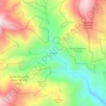
Name: Valley topographic map, elevation, terrain.
Location: Valley, Avery County, North Carolina, United States (36.06457 -82.06123 36.10457 -82.02123)
Average elevation: 4,150 ft
Minimum elevation: 2,982 ft
Maximum elevation: 5,456 ft
Other topographic maps
Click on a map to view its topography, its elevation and its terrain.
Banner Elk
United States > North Carolina > Avery County
Banner Elk is nestled within the Blue Ridge Mountains, characterized by rugged and varied terrain. The town itself sits at an elevation of around 3,700 feet, offering expansive views of the surrounding peaks and valleys. This region, part of the southern Appalachian range, includes steep slopes, dense forests,…
Average elevation: 3,822 ft
Newland
United States > North Carolina > Avery County
At an elevation of 3,621 feet or 1,104 metres, it is the highest county seat in the Eastern United States (based on elevations in the USGS database).
Average elevation: 3,740 ft
Sugar Mountain
United States > North Carolina > Avery County
Sugar Mountain has a humid continental climate (Dfb) with warm summers and moderately cold winters, though very cold by North Carolina standards. Due to the village's high elevation, one can experiences all four seasons in equal length on the mountain.
Average elevation: 4,301 ft
Banner Elk
United States > North Carolina > Avery County
Banner Elk is located in North America's humid continental climate zone due to its elevation, which gives it a climate more like that of Altoona, Pennsylvania, than Asheville, North Carolina, during the winter. During the summer the temperatures are much like a mountain lake town in New Hampshire. The town…
Average elevation: 3,819 ft
Newland
United States > North Carolina > Avery County
At an elevation of 3,621 feet or 1,104 metres, it is the highest county seat in the Eastern United States (based on elevations in the USGS database).
Average elevation: 3,740 ft
Banner Elk
United States > North Carolina > Avery County
Banner Elk is located in North America's humid continental climate zone due to its elevation, which gives it a climate more like that of Altoona, Pennsylvania, than Asheville, North Carolina, during the winter. During the summer the temperatures are much like a mountain lake town in New Hampshire. The town…
Average elevation: 3,819 ft
Sugar Mountain
United States > North Carolina > Avery County
Sugar Mountain has a humid continental climate (Dfb) with warm summers and moderately cold winters, though very cold by North Carolina standards. Due to the village's high elevation, one can experiences all four seasons in equal length on the mountain.
Average elevation: 4,301 ft
Banner Elk
United States > North Carolina > Avery County
Banner Elk is located in North America's humid continental climate zone due to its elevation, which gives it a climate more like that of Altoona, Pennsylvania, than Asheville, North Carolina, during the winter. During the summer the temperatures are much like a mountain lake town in New Hampshire. The town…
Average elevation: 3,819 ft
Newland
United States > North Carolina > Avery County
At an elevation of 3,621 feet or 1,104 metres, it is the highest county seat in the Eastern United States (based on elevations in the USGS database).
Average elevation: 3,740 ft