
Make a donation
Gear up for your next adventure:
As an Amazon Associate, this site earns from qualifying purchases at no extra cost to you.
Cam Ranh topographic map
Click on the map to display elevation.
Make a donation
Gear up for your next adventure:
As an Amazon Associate, this site earns from qualifying purchases at no extra cost to you.
About this map
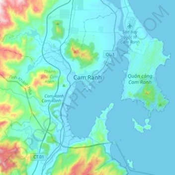
Name: Cam Ranh topographic map, elevation, terrain.
Location: Cam Ranh, Khánh Hòa Province, Vietnam (11.76895 109.00019 12.03096 109.28405)
Average elevation: 427 ft
Minimum elevation: -3 ft
Maximum elevation: 3,747 ft
Make a donation
Gear up for your next adventure:
As an Amazon Associate, this site earns from qualifying purchases at no extra cost to you.
Other topographic maps
Click on a map to view its topography, its elevation and its terrain.
Make a donation
Gear up for your next adventure:
As an Amazon Associate, this site earns from qualifying purchases at no extra cost to you.
Southwest Cay
Vietnam > Khanh Hoa province > Trường Sa District > Xã Song Tử Tây
Average elevation: 0 ft
Sin Cowe East Island
Vietnam > Khanh Hoa province > Trường Sa District > Sinh Tồn Đông
Average elevation: 0 ft
Central London Reef
Vietnam > Khanh Hoa province > Trường Sa District > Trường Sa
Average elevation: 0 ft
Make a donation
Gear up for your next adventure:
As an Amazon Associate, this site earns from qualifying purchases at no extra cost to you.
Make a donation
Gear up for your next adventure:
As an Amazon Associate, this site earns from qualifying purchases at no extra cost to you.
Make a donation
Gear up for your next adventure:
As an Amazon Associate, this site earns from qualifying purchases at no extra cost to you.