
Parque Provincial Copahue - Caviahue topographic map
Interactive map
Click on the map to display elevation.
About this map
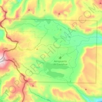
Name: Parque Provincial Copahue - Caviahue topographic map, elevation, terrain.
Average elevation: 6,240 ft
Minimum elevation: 4,304 ft
Maximum elevation: 9,656 ft
Other topographic maps
Click on a map to view its topography, its elevation and its terrain.
Volcán Domuyo
Volcán Domuyo, Departamento Chos Malal, NQN, Argentina
Average elevation: 13,875 ft
Cerro Mocho
Cerro Mocho, Departamento Lácar, NQN, Argentina
Average elevation: 3,730 ft