
Volcán Domuyo topographic map
Interactive map
Click on the map to display elevation.
About this map
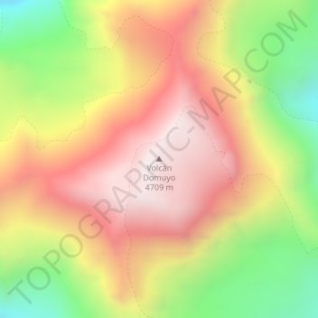
Name: Volcán Domuyo topographic map, elevation, terrain.
Location: Volcán Domuyo, Departamento Chos Malal, NQN, Argentina (-36.63665 -70.43132 -36.63655 -70.43122)
Average elevation: 13,875 ft
Minimum elevation: 11,998 ft
Maximum elevation: 15,420 ft
Other topographic maps
Click on a map to view its topography, its elevation and its terrain.
Cerro Mocho
Cerro Mocho, Departamento Lácar, NQN, Argentina
Average elevation: 3,730 ft
Parque Provincial Copahue - Caviahue
Parque Provincial Copahue - Caviahue, RP26, Lafontaine, Departamento Ñorquín, NQN, 8349, Argentina
Average elevation: 6,240 ft