
Make a donation
Gear up for your next adventure:
As an Amazon Associate, this site earns from qualifying purchases at no extra cost to you.
Brymbo topographic map
Click on the map to display elevation.
Make a donation
Gear up for your next adventure:
As an Amazon Associate, this site earns from qualifying purchases at no extra cost to you.
Brymbo
While there was mining of coal in the area on a small scale, the late eighteenth century saw an expansion in activity, particularly after the industrialist John "Iron-Mad" Wilkinson purchased Brymbo Hall and began developing its estate, mining coal and ironstone and building an ironworks which was later to become the Brymbo Steelworks. By 1821 there was a total of 41 coal pits on the Brymbo Hall estate alone. In the nineteenth century, a number of larger deep mines were sunk around the area, and the majority of the village of Brymbo was developed as accommodation for the miners and ironworkers. The village itself was constructed on and around the steep sides of Brymbo Hill with views towards the Cheshire Plain, though the area's topography was later to cause problems when the steelworks expanded in 1956: the new parts had to be built on a vast artificial plateau of slag from the furnaces, filling the width of the valley and burying most of the village of Lodge, whose houses were purchased and demolished.
Make a donation
Gear up for your next adventure:
As an Amazon Associate, this site earns from qualifying purchases at no extra cost to you.
About this map
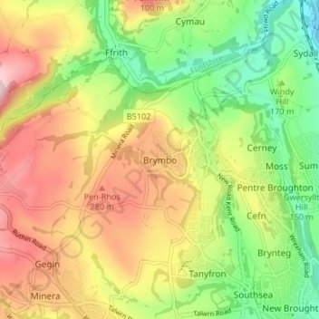
Name: Brymbo topographic map, elevation, terrain.
Location: Brymbo, Wrexham, Wales, LL11 5AS, United Kingdom (53.05664 -3.08078 53.09664 -3.04078)
Average elevation: 640 ft
Minimum elevation: 230 ft
Maximum elevation: 1,106 ft
Make a donation
Gear up for your next adventure:
As an Amazon Associate, this site earns from qualifying purchases at no extra cost to you.
Other topographic maps
Click on a map to view its topography, its elevation and its terrain.
Make a donation
Gear up for your next adventure:
As an Amazon Associate, this site earns from qualifying purchases at no extra cost to you.