
Thank you for supporting this site ❤️
Make a donation
Make a donation
Gear up for your next adventure:
As an Amazon Associate, this site earns from qualifying purchases at no extra cost to you.
Acremont topographic map
Click on the map to display elevation.
Thank you for supporting this site ❤️
Make a donation
Make a donation
Gear up for your next adventure:
As an Amazon Associate, this site earns from qualifying purchases at no extra cost to you.
About this map
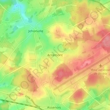
Name: Acremont topographic map, elevation, terrain.
Location: Acremont, Bertrix, Neufchâteau, Luxembourg, Wallonie, Belgique (49.87771 5.19182 49.91771 5.23182)
Average elevation: 1,434 ft
Minimum elevation: 1,286 ft
Maximum elevation: 1,555 ft
Thank you for supporting this site ❤️
Make a donation
Make a donation
Gear up for your next adventure:
As an Amazon Associate, this site earns from qualifying purchases at no extra cost to you.