
Make a donation
Gear up for your next adventure:
As an Amazon Associate, this site earns from qualifying purchases at no extra cost to you.
Watertown topographic map
Click on the map to display elevation.
Make a donation
Gear up for your next adventure:
As an Amazon Associate, this site earns from qualifying purchases at no extra cost to you.
Watertown
Watertown is in southeastern Litchfield County and is bordered to the southeast by the city of Waterbury in New Haven County. Other bordering towns are Middlebury to the south, Woodbury and Bethlehem to the west, Morris to the northwest, and Thomaston to the east. It is in the Eastern Standard time zone. The elevation at the town center is 583 feet (178 m).
Make a donation
Gear up for your next adventure:
As an Amazon Associate, this site earns from qualifying purchases at no extra cost to you.
About this map
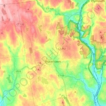
Name: Watertown topographic map, elevation, terrain.
Average elevation: 653 ft
Minimum elevation: 246 ft
Maximum elevation: 1,102 ft
Naugatuck Valley Planning Region trails, hiking, mountain biking, running and outdoor activities
Make a donation
Gear up for your next adventure:
As an Amazon Associate, this site earns from qualifying purchases at no extra cost to you.
Other topographic maps
Click on a map to view its topography, its elevation and its terrain.
Huntington
United States > Connecticut > Naugatuck Valley Planning Region > Shelton
Average elevation: 364 ft
Minortown
United States > Connecticut > Naugatuck Valley Planning Region > Woodbury
Average elevation: 554 ft
White Hills
United States > Connecticut > Naugatuck Valley Planning Region > Shelton
Average elevation: 407 ft
Make a donation
Gear up for your next adventure:
As an Amazon Associate, this site earns from qualifying purchases at no extra cost to you.
Mad River
United States > Connecticut > Naugatuck Valley Planning Region > Waterbury > Fair Lawn
Average elevation: 440 ft
Fox Hollow
United States > Connecticut > Naugatuck Valley Planning Region > Cheshire
Average elevation: 210 ft
Westview Heights
United States > Connecticut > Naugatuck Valley Planning Region > Middlebury
Average elevation: 522 ft
Union City
United States > Connecticut > Naugatuck Valley Planning Region > Naugatuck
Average elevation: 407 ft
Make a donation
Gear up for your next adventure:
As an Amazon Associate, this site earns from qualifying purchases at no extra cost to you.
Warsaw Park
United States > Connecticut > Naugatuck Valley Planning Region > Ansonia
Average elevation: 351 ft
Bunker Hill
United States > Connecticut > Naugatuck Valley Planning Region > Waterbury
Average elevation: 459 ft
Cedar Land
United States > Connecticut > Naugatuck Valley Planning Region > Southbury
Average elevation: 338 ft
Town Plot Hill
United States > Connecticut > Naugatuck Valley Planning Region > Waterbury
Average elevation: 417 ft
Make a donation
Gear up for your next adventure:
As an Amazon Associate, this site earns from qualifying purchases at no extra cost to you.
Millville
United States > Connecticut > Naugatuck Valley Planning Region > Naugatuck
Average elevation: 433 ft
Bunker Hill
United States > Connecticut > Naugatuck Valley Planning Region > Waterbury
Average elevation: 459 ft
Bunker Hill
United States > Connecticut > Naugatuck Valley Planning Region > Waterbury
Average elevation: 459 ft
Traditions
United States > Connecticut > Naugatuck Valley Planning Region > Southbury > South Britain
Average elevation: 367 ft
Make a donation
Gear up for your next adventure:
As an Amazon Associate, this site earns from qualifying purchases at no extra cost to you.
Minortown
United States > Connecticut > Naugatuck Valley Planning Region > Woodbury
Average elevation: 554 ft
Gulls Hollow
United States > Connecticut > Naugatuck Valley Planning Region > Bethlehem
Average elevation: 797 ft
Allentown
United States > Connecticut > Naugatuck Valley Planning Region > Plymouth
Average elevation: 801 ft
Make a donation
Gear up for your next adventure:
As an Amazon Associate, this site earns from qualifying purchases at no extra cost to you.