
Isla Isabela topographic map
Click on the map to display elevation.
Isla Isabela
One of the youngest islands, Isabela is located on the western edge of the archipelago near the Galápagos hotspot. At approximately 1 million years old, the seahorse-shaped island was formed by the merger of six shield volcanoes; Alcedo, Cerro Azul, Darwin, Ecuador, Sierra Negra, and Wolf. All of these volcanoes except Ecuador are still active, making it one of the most volcanically active places on earth. Two of the volcanoes, Volcan Ecuador and Volcan Wolf (the island's highest point with an elevation of 1,707 m [5,600 ft]), lie directly on the equator. The island is primarily noted for its geology, providing excellent examples of a geologic occurrence that created the Galápagos Islands including uplifts at Urbina Bay and the Bolivar Channel, tuff cones at Tagus Cove, and Pulmace on Alcedo and Sierra Negra, one of the most active volcanoes in the world.
About this map
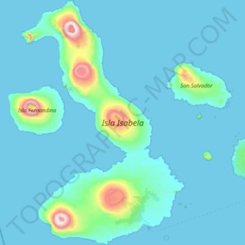
Name: Isla Isabela topographic map, elevation, terrain.
Location: Isla Isabela, Galápagos, Ecuador (-1.05406 -91.59387 0.16428 -90.78088)
Average elevation: 315 ft
Minimum elevation: -3 ft
Maximum elevation: 5,522 ft
Other topographic maps
Click on a map to view its topography, its elevation and its terrain.
Wolf
Ecuador > Galápagos > Cantón Isabela
Wolf Island (Spanish: Isla Wolf) is a small island in the northern Galápagos Islands. It has an area of 1.3 km2 (0.5 sq mi) and a maximum altitude of 253 m (830 ft) above sea level. The island is remote from the main archipelago and has no permanent population. The Galápagos National Park does not allow…
Average elevation: 49 ft
Isla Plaza Sur
Ecuador > Galápagos > Cantón Santa Cruz
South Plaza (Spanish: Isla Plaza Sur) is a small island off the east coast of Santa Cruz in the Galápagos Islands. It has an area of 0.13 km2 and a maximum altitude of 23 metres.
Average elevation: 16 ft
Punta Chacabuco
Ecuador > Galápagos > Cantón San Cristóbal > Parroquia Puerto Baquerizo Moreno
Average elevation: 39 ft
Isla Pinzón
Ecuador > Galápagos > Cantón Santa Cruz
Pinzón or Pinzon Island (Spanish: Isla Pinzón) is an island in Ecuador's Galápagos Archipelago. It has no permanent population, an area of 18 square kilometers (6.9 sq mi), and a maximum elevation of 458 meters (1,503 ft). Home to giant Galápagos tortoises of the subspecies Chelonoidis duncanensis and…
Average elevation: 407 ft
Roca Redonda
Ecuador > Galápagos > Cantón Isabela
Redonda Rock (Spanish: Roca Redonda, "Round Rock") is a flat-topped, steep-sided islet located roughly 25 km (16 mi) northwest of the island of Isabela in Ecuador's Galápagos Islands. Redonda measures 100 m (330 ft) long and 50 m (160 ft) wide with a maximum elevation of 67 m (220 ft). Its isolation and…
Average elevation: 0 ft