
Make a donation
Gear up for your next adventure:
As an Amazon Associate, this site earns from qualifying purchases at no extra cost to you.
Marchena Island topographic map
Click on the map to display elevation.
Make a donation
Gear up for your next adventure:
As an Amazon Associate, this site earns from qualifying purchases at no extra cost to you.
About this map
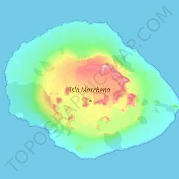
Name: Marchena Island topographic map, elevation, terrain.
Location: Marchena Island, Cantón Santa Cruz, Galápagos, Ecuador (0.27666 -90.54267 0.38680 -90.40060)
Average elevation: 167 ft
Minimum elevation: -3 ft
Maximum elevation: 1,099 ft
Make a donation
Gear up for your next adventure:
As an Amazon Associate, this site earns from qualifying purchases at no extra cost to you.
Other topographic maps
Click on a map to view its topography, its elevation and its terrain.
Isla Santa Cruz
Ecuador > Galápagos > Cantón Santa Cruz
Santa Cruz Island (Spanish: Isla Santa Cruz), also known as Indefatigable Island and by other names, is the most populous and second-largest island in the Galápagos Islands, Ecuador. Situated in the middle of the group, Santa Cruz is a shield volcano with an area of 986 km2 (381 sq mi) and a maximum altitude…
Average elevation: 312 ft
Marchena Island
Ecuador > Galápagos > Cantón Santa Cruz
Marchena Island (Spanish: Isla Marchena) is one of the Galapagos Islands in Ecuador. It has an area of 130 square kilometers (50 sq mi) and reaches an elevation of 343 meters (1,125 ft) above sea level. The island does not receive visitors, although the surrounding water is used by aquatic divers on organized…
Average elevation: 164 ft
Make a donation
Gear up for your next adventure:
As an Amazon Associate, this site earns from qualifying purchases at no extra cost to you.
Isla Santa Cruz
Ecuador > Galápagos > Cantón Santa Cruz
Santa Cruz Island (Spanish pronunciation: [ˈsanta ˈkɾus]) is one of the Galápagos Islands with an area of 986 km2 (381 sq mi) and a maximum altitude of 864 metres (2,835 ft). Situated in the center of the archipelago, Santa Cruz is the second largest island after Isabela. Its capital is Puerto Ayora, the…
Average elevation: 312 ft
Make a donation
Gear up for your next adventure:
As an Amazon Associate, this site earns from qualifying purchases at no extra cost to you.
Make a donation
Gear up for your next adventure:
As an Amazon Associate, this site earns from qualifying purchases at no extra cost to you.
Isla Pinta
Ecuador > Galápagos > Cantón Santa Cruz
Pinta Island (Spanish: Isla Pinta) is one of the Galápagos Islands in Ecuador, west of South America. Pinta has an area of 60 km2 (23 sq mi) and a maximum altitude of 777 meters (2,549 ft).
Average elevation: 253 ft