
Thank you for supporting this site ❤️
Make a donation
Make a donation
Gear up for your next adventure:
As an Amazon Associate, this site earns from qualifying purchases at no extra cost to you.
Cotos topographic map
Click on the map to display elevation.
Thank you for supporting this site ❤️
Make a donation
Make a donation
Gear up for your next adventure:
As an Amazon Associate, this site earns from qualifying purchases at no extra cost to you.
About this map
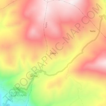
Name: Cotos topographic map, elevation, terrain.
Location: Cotos, Turpo, Andahuaylas, Apurímac, Perú (-13.75278 -73.51627 -13.71278 -73.47627)
Average elevation: 12,316 ft
Minimum elevation: 10,735 ft
Maximum elevation: 13,255 ft
Thank you for supporting this site ❤️
Make a donation
Make a donation
Gear up for your next adventure:
As an Amazon Associate, this site earns from qualifying purchases at no extra cost to you.