
Make a donation
Gear up for your next adventure:
As an Amazon Associate, this site earns from qualifying purchases at no extra cost to you.
Coffee Pot Bayou topographic map
Click on the map to display elevation.
Make a donation
Gear up for your next adventure:
As an Amazon Associate, this site earns from qualifying purchases at no extra cost to you.
About this map
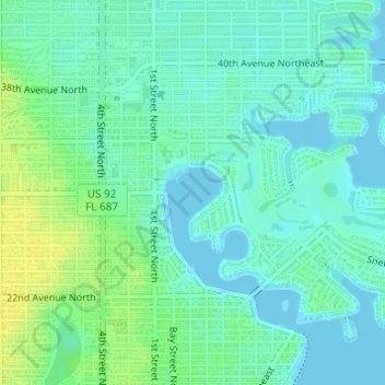
Name: Coffee Pot Bayou topographic map, elevation, terrain.
Average elevation: 23 ft
Minimum elevation: -3 ft
Maximum elevation: 69 ft
Pinellas County trails, hiking, mountain biking, running and outdoor activities
Make a donation
Gear up for your next adventure:
As an Amazon Associate, this site earns from qualifying purchases at no extra cost to you.
Other topographic maps
Click on a map to view its topography, its elevation and its terrain.
West and East Lealman
United States > Florida > Pinellas County > Saint Petersburg
"West and East Lealman" was located at 27°49′12″N 82°41′12″W / 27.82000°N 82.68667°W / 27.82000; -82.68667 (27.820103, -82.686670). The community is adjacent to the cities of Pinellas Park, St. Petersburg, and Kenneth City. The elevation is 49 feet (15 m) above sea level.
Average elevation: 39 ft