Geolocate

Compstall topographic map

Click on the map to display elevation.

About this map

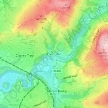
Name: Compstall topographic map, elevation, terrain.

Location: Compstall, Stockport, Greater Manchester, England, SK6 5HU, United Kingdom (53.39538 -2.07516 53.43538 -2.03516)

Average elevation: 495 ft

Minimum elevation: 187 ft

Maximum elevation: 974 ft

Other topographic maps

Click on a map to view its topography, its elevation and its terrain.

River Mersey

United Kingdom > England > Stockport

Average elevation: 223 ft

Gear up for your next adventure:

🧢Outdoor Hiking Hat - Sun protection hat for outdoor explorers
Backpacking Tents - Weight-optimized shelters for multi-day topographic surveys
🩳Quick‑Dry Hiking Shorts - Comfortable and quick‑dry shorts for summer hiking
🧭Outdoor Navigation Book - Learn advanced navigation skills
🎁Geography Themed Gifts - Unique gift ideas for map lovers and geography enthusiasts

As an Amazon Associate, this site earns from qualifying purchases at no extra cost to you.