Geolocate

Lar topographic map

Click on the map to display elevation.

About this map

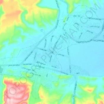
Name: Lar topographic map, elevation, terrain.

Location: Lar, بخش مرکزی, Larestan County, Fars Province, Iran (27.62594 54.27735 27.69789 54.36790)

Average elevation: 2,831 ft

Minimum elevation: 2,631 ft

Maximum elevation: 3,658 ft

Gear up for your next adventure:

Backpacking Tents - Weight-optimized shelters for multi-day topographic surveys
🚪Portable Camp Chair - Foldable chair for comfort at camp
🦶Carbon Trekking Poles - Reduce knee impact on steep descents with ultra-light poles
🛡️Bear Spray Outdoor - Protection in bear country hikes
🏕️Tent Footprint - Protect your tent base from wear

As an Amazon Associate, this site earns from qualifying purchases at no extra cost to you.