
Thank you for supporting this site ❤️
Make a donation
Make a donation
Gear up for your next adventure:
As an Amazon Associate, this site earns from qualifying purchases at no extra cost to you.
O Muíño topographic map
Click on the map to display elevation.
Thank you for supporting this site ❤️
Make a donation
Make a donation
Gear up for your next adventure:
As an Amazon Associate, this site earns from qualifying purchases at no extra cost to you.
About this map
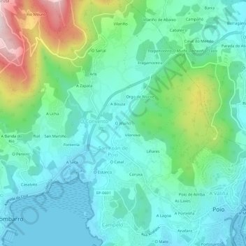
Name: O Muíño topographic map, elevation, terrain.
Location: O Muíño, Poio, Pontevedra, Galicia, 36994, España (42.42726 -8.70015 42.46726 -8.66015)
Average elevation: 358 ft
Minimum elevation: -7 ft
Maximum elevation: 1,470 ft
Thank you for supporting this site ❤️
Make a donation
Make a donation
Gear up for your next adventure:
As an Amazon Associate, this site earns from qualifying purchases at no extra cost to you.