
Geisenfeld topographic map
Click on the map to display elevation.
About this map
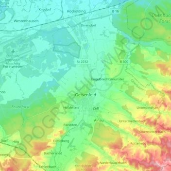
Name: Geisenfeld topographic map, elevation, terrain.
Average elevation: 1,283 ft
Minimum elevation: 1,155 ft
Maximum elevation: 1,627 ft
Other topographic maps
Click on a map to view its topography, its elevation and its terrain.
Straßhöfe
Deutschland > Bayern > Landkreis Pfaffenhofen an der Ilm > Rohrbach an der Ilm
Average elevation: 1,398 ft
Holzleiten
Deutschland > Bayern > Landkreis Pfaffenhofen an der Ilm > Geisenfeld
Average elevation: 1,266 ft
Gotteshofen
Deutschland > Bayern > Landkreis Pfaffenhofen an der Ilm > Reichertshofen > Reichertshofen
Average elevation: 1,273 ft
Raitbach
Deutschland > Bayern > Landkreis Pfaffenhofen an der Ilm > Pörnbach
Average elevation: 1,447 ft
Pleiling
Deutschland > Bayern > Landkreis Pfaffenhofen an der Ilm > Vohburg an der Donau > Pleiling
Average elevation: 1,312 ft
Untermettenbach
Deutschland > Bayern > Landkreis Pfaffenhofen an der Ilm > Geisenfeld > Untermettenbach
Average elevation: 1,378 ft
Fahlenbach
Deutschland > Bayern > Landkreis Pfaffenhofen an der Ilm > Rohrbach
Average elevation: 1,352 ft
Weingarten
Deutschland > Bayern > Landkreis Pfaffenhofen an der Ilm > Pfaffenhofen an der Ilm > Haimpertshofen
Average elevation: 1,480 ft
Fürholzen
Deutschland > Bayern > Landkreis Pfaffenhofen an der Ilm > Rohrbach
Average elevation: 1,417 ft
Haimpertshofen
Deutschland > Bayern > Landkreis Pfaffenhofen an der Ilm > Pfaffenhofen an der Ilm
Average elevation: 1,470 ft
Gaden
Deutschland > Bayern > Landkreis Pfaffenhofen an der Ilm > Geisenfeld
Average elevation: 1,266 ft
Lueg
Deutschland > Bayern > Landkreis Pfaffenhofen an der Ilm > Jetzendorf
Average elevation: 1,637 ft
Eichelberg
Deutschland > Bayern > Landkreis Pfaffenhofen an der Ilm > Geisenfeld
Average elevation: 1,319 ft
Engelbrechtsmünster
Deutschland > Bayern > Landkreis Pfaffenhofen an der Ilm > Geisenfeld
Average elevation: 1,257 ft
Siebeneichmühle
Deutschland > Bayern > Landkreis Pfaffenhofen an der Ilm > Pfaffenhofen an der Ilm > Affalterbach
Average elevation: 1,444 ft
Wasenstatt
Deutschland > Bayern > Landkreis Pfaffenhofen an der Ilm > Pfaffenhofen an der Ilm > Göbelsbach
Average elevation: 1,480 ft
Gambach
Deutschland > Bayern > Landkreis Pfaffenhofen an der Ilm > Rohrbach an der Ilm
Average elevation: 1,444 ft
Hög
Deutschland > Bayern > Landkreis Pfaffenhofen an der Ilm > Reichertshofen
Average elevation: 1,345 ft
Tegernbach
Deutschland > Bayern > Landkreis Pfaffenhofen an der Ilm > Pfaffenhofen an der Ilm > Tegernbach
Average elevation: 1,503 ft
Knodorf
Deutschland > Bayern > Landkreis Pfaffenhofen an der Ilm > Vohburg an der Donau
Average elevation: 1,181 ft
Rottenegg
Deutschland > Bayern > Landkreis Pfaffenhofen an der Ilm > Geisenfeld
Average elevation: 1,440 ft
Grafing
Deutschland > Bayern > Landkreis Pfaffenhofen an der Ilm > Grafing
Average elevation: 1,572 ft
Affalterbach
Deutschland > Bayern > Landkreis Pfaffenhofen an der Ilm > Pfaffenhofen an der Ilm > Affalterbach
Average elevation: 1,440 ft
Siebeneich
Deutschland > Bayern > Landkreis Pfaffenhofen an der Ilm > Kohlstatt > Siebeneich
Average elevation: 1,631 ft
Jebertshausen
Deutschland > Bayern > Landkreis Pfaffenhofen an der Ilm > Wolnzach > Jebertshausen
Average elevation: 1,473 ft
Egg
Deutschland > Bayern > Landkreis Pfaffenhofen an der Ilm > Wolnzach > Egg
Average elevation: 1,581 ft
Sankt Kastl
Deutschland > Bayern > Landkreis Pfaffenhofen an der Ilm > Stöffel > Sankt Kastl
Average elevation: 1,417 ft
Hagberg
Deutschland > Bayern > Landkreis Pfaffenhofen an der Ilm > Hettenshausen
Average elevation: 1,486 ft
Oberhartheim
Deutschland > Bayern > Landkreis Pfaffenhofen an der Ilm > Vohburg an der Donau
Average elevation: 1,293 ft
Rottenegg
Deutschland > Bayern > Landkreis Pfaffenhofen an der Ilm > Geisenfeld
Average elevation: 1,440 ft