
Make a donation
Gear up for your next adventure:
As an Amazon Associate, this site earns from qualifying purchases at no extra cost to you.
Aiguille du Plan topographic map
Click on the map to display elevation.
Make a donation
Gear up for your next adventure:
As an Amazon Associate, this site earns from qualifying purchases at no extra cost to you.
About this map
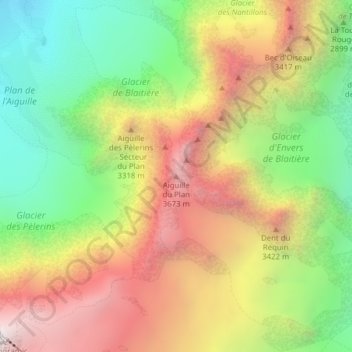
Name: Aiguille du Plan topographic map, elevation, terrain.
Average elevation: 9,695 ft
Minimum elevation: 7,254 ft
Maximum elevation: 12,405 ft
Make a donation
Gear up for your next adventure:
As an Amazon Associate, this site earns from qualifying purchases at no extra cost to you.
Other topographic maps
Click on a map to view its topography, its elevation and its terrain.
Mer de Glace
France > Auvergne-Rhône-Alpes > Upper Savoy > Chamonix-Mont-Blanc
The glacier lies above the Chamonix valley. The pressure within the ice is known to reach at least 30 atmospheres. The Mer de Glace can be considered as originating at an elevation of 2,100 metres (6,900 ft), just north of the Aiguille du Tacul, where it is formed by the confluence of the Glacier de Leschaux…
Average elevation: 7,621 ft
Mer de Glace
France > Auvergne-Rhône-Alpes > Upper Savoy > Chamonix-Mont-Blanc
The glacier lies above the Chamonix valley. The pressure within the ice is known to reach at least 30 atmospheres. The Mer de Glace can be considered as originating at an elevation of 2,100 metres (6,900 ft), just north of the Aiguille du Tacul [fr], where it is formed by the confluence of the Glacier de…
Average elevation: 7,618 ft
Réserve naturelle des Aiguilles rouges
France > Auvergne-Rhône-Alpes > Upper Savoy > Chamonix-Mont-Blanc
Average elevation: 6,401 ft
Glacier des Bossons
France > Auvergne-Rhône-Alpes > Upper Savoy > Chamonix-Mont-Blanc
In 1900 the snout of the glacier was still reaching down into the valley bottom at an altitude of 1,050 metres above sea level. By 1980 the snout only reached down to about 1,200 metres, and by 2008 it had melted backwards even further backwards, ended at around 1,400 metres, albeit still well below the…
Average elevation: 10,295 ft
Make a donation
Gear up for your next adventure:
As an Amazon Associate, this site earns from qualifying purchases at no extra cost to you.
Lac Blanc
France > Auvergne-Rhône-Alpes > Upper Savoy > Chamonix-Mont-Blanc
Average elevation: 7,710 ft