Geolocate

Bridger topographic map

Click on the map to display elevation.

About this map

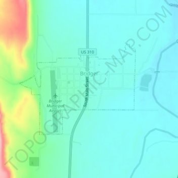
Name: Bridger topographic map, elevation, terrain.

Location: Bridger, Carbon County, Montana, 59014, United States (45.28648 -108.92881 45.30026 -108.90375)

Average elevation: 3,707 ft

Minimum elevation: 3,602 ft

Maximum elevation: 4,098 ft

Carbon County trails, hiking, mountain biking, running and outdoor activities

Other topographic maps

Click on a map to view its topography, its elevation and its terrain.

Alpine

United States > Montana > Carbon County

Average elevation: 7,385 ft

Silesia

United States > Montana > Carbon County

Average elevation: 3,468 ft

Rockvale

United States > Montana > Carbon County

Average elevation: 3,533 ft

Gear up for your next adventure:

🏕️Tent Footprint - Protect your tent base from wear
🧢Sun Protection Hats - Wide-brimmed and UPF-rated hats for high-altitude sun safety
🩹Survival Bandages - High‑quality bandages for emergencies
🧷Carabiner Set - Durable clips for gear attachment
🛏️Cold Weather Sleeping Bag - Warm sleeping bag for cold conditions

As an Amazon Associate, this site earns from qualifying purchases at no extra cost to you.