
Make a donation
Gear up for your next adventure:
As an Amazon Associate, this site earns from qualifying purchases at no extra cost to you.
Wiscasset topographic map
Click on the map to display elevation.
Make a donation
Gear up for your next adventure:
As an Amazon Associate, this site earns from qualifying purchases at no extra cost to you.
About this map
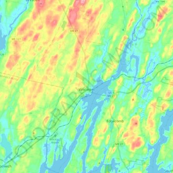
Name: Wiscasset topographic map, elevation, terrain.
Location: Wiscasset, Lincoln County, Maine, 04578, United States (43.92726 -69.74633 44.08815 -69.62364)
Average elevation: 115 ft
Minimum elevation: -30 ft
Maximum elevation: 358 ft
Lincoln County trails, hiking, mountain biking, running and outdoor activities
Make a donation
Gear up for your next adventure:
As an Amazon Associate, this site earns from qualifying purchases at no extra cost to you.
Other topographic maps
Click on a map to view its topography, its elevation and its terrain.
West Boothbay Harbor
United States > Maine > Lincoln County > Boothbay Harbor
Average elevation: 33 ft
Make a donation
Gear up for your next adventure:
As an Amazon Associate, this site earns from qualifying purchases at no extra cost to you.
Monhegan Island
United States > Maine > Lincoln County > Monhegan Island Plantation > Monhegan
Average elevation: 16 ft
Make a donation
Gear up for your next adventure:
As an Amazon Associate, this site earns from qualifying purchases at no extra cost to you.