
Wrington topographic map
Click on the map to display elevation.
About this map
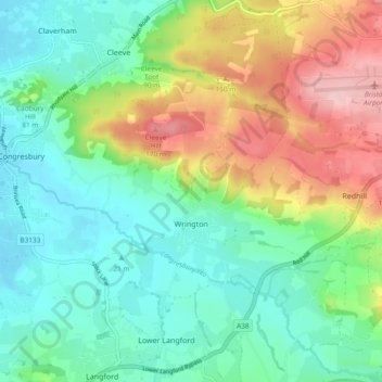
Name: Wrington topographic map, elevation, terrain.
Location: Wrington, North Somerset, England, United Kingdom (51.33718 -2.78265 51.39590 -2.69669)
Average elevation: 220 ft
Minimum elevation: 13 ft
Maximum elevation: 643 ft
Other topographic maps
Click on a map to view its topography, its elevation and its terrain.
Upper Canada
United Kingdom > England > North Somerset > Hutton > Upper Canada
Average elevation: 157 ft