
Thank you for supporting this site ❤️
Make a donation
Make a donation
Gear up for your next adventure:
As an Amazon Associate, this site earns from qualifying purchases at no extra cost to you.
Larbatache topographic map
Click on the map to display elevation.
Thank you for supporting this site ❤️
Make a donation
Make a donation
Gear up for your next adventure:
As an Amazon Associate, this site earns from qualifying purchases at no extra cost to you.
About this map
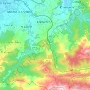
Name: Larbatache topographic map, elevation, terrain.
Location: Larbatache, Daïra Khemis El Khechna, Boumerdès, 35017, Algérie (36.55079 3.30426 36.66543 3.41468)
Average elevation: 1,119 ft
Minimum elevation: 151 ft
Maximum elevation: 3,386 ft
Thank you for supporting this site ❤️
Make a donation
Make a donation
Gear up for your next adventure:
As an Amazon Associate, this site earns from qualifying purchases at no extra cost to you.
Other topographic maps
Click on a map to view its topography, its elevation and its terrain.