
Make a donation
Gear up for your next adventure:
As an Amazon Associate, this site earns from qualifying purchases at no extra cost to you.
Riverside State Park topographic map
Click on the map to display elevation.
Make a donation
Gear up for your next adventure:
As an Amazon Associate, this site earns from qualifying purchases at no extra cost to you.
Riverside State Park
Terrain in park is varied, with steep valleys along the rivers and more flat plateaus above. The Spokane River falls from approximately 1,680 feet when it enters the park in the south to approximately 1,540 feet at the Long Lake Reservoir on the northern edge of the park. Surrounding plateaus rise to 2,200 feet in places less than one mile west of the river. Mountains flanking the northern edge of the Little Spokane River valley rise even higher, to above 3,100 feet. The Spokane River meanders in northwesterly direction through the park in a thin, steep valley with only a handful of flat expanses less than 100 feet above the river level. There are multiple areas of nearly or fully sheer cliff drops of 100 feet or more throughout the park as the terrain rises from the river. As a result of this topography, there are multiple areas of whitewater rapids along the Spokane River. On the other hand, the valley of the Little Spokane River tends to be wider with many wetlands and oxbow lakes characteristic of a meandering stream. The Little Spokane falls from 1,560 feet at Waikiki Road when it enters the park 1,540 feet at its confluence with the Spokane River, a drop of just 20 feet over a straight-line distance of more than four miles (though the many meanders make its course considerably longer than the straight-line distance).
Make a donation
Gear up for your next adventure:
As an Amazon Associate, this site earns from qualifying purchases at no extra cost to you.
About this map
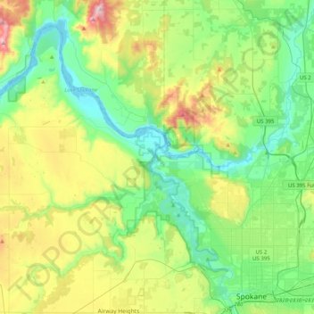
Name: Riverside State Park topographic map, elevation, terrain.
Average elevation: 2,116 ft
Minimum elevation: 1,522 ft
Maximum elevation: 3,553 ft
Spokane County trails, hiking, mountain biking, running and outdoor activities
Make a donation
Gear up for your next adventure:
As an Amazon Associate, this site earns from qualifying purchases at no extra cost to you.
Other topographic maps
Click on a map to view its topography, its elevation and its terrain.