Village of Waterford topographic map
Click on the map to display elevation.
About this map

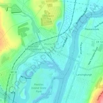
Name: Village of Waterford topographic map, elevation, terrain.
Average elevation: 72 ft
Minimum elevation: -7 ft
Maximum elevation: 315 ft
While much of the surrounding town has a high elevation, the Village of Waterford is very low relative to the two major rivers forming its borders. Its position at the convergence of both the Erie and Champlain Canals as well as the Mohawk and Hudson Rivers, has contributed to many floods. While major floods have been rare through the last half of the 20th century to the present, the most recent flood of significance was in late June and early July 2006. The flood forced the closing of the Erie Canal, stranding several boats in the locks.
Other topographic maps
Click on a map to view its topography, its elevation and its terrain.

Saratoga Springs
United States > New York > Saratoga County
Saratoga Springs, City of Saratoga Springs, Saratoga County, New York, 12866, United States
Average elevation: 528 ft

Town of Clifton Park
United States > New York > Saratoga County
Town of Clifton Park, Saratoga County, New York, United States
Average elevation: 279 ft

Gansevoort
United States > New York > Saratoga County
Gansevoort, Town of Northumberland, Saratoga County, New York, United States
Average elevation: 226 ft

Quaker Springs
United States > New York > Saratoga County
Quaker Springs, Town of Saratoga, Saratoga County, New York, United States
Average elevation: 335 ft

Greenfield Center
United States > New York > Saratoga County
Greenfield Center, Town of Greenfield, Saratoga County, New York, 12833, United States
Average elevation: 669 ft

Town of Milton
United States > New York > Saratoga County
Town of Milton, Saratoga County, New York, United States
Average elevation: 384 ft

Ballston Center
United States > New York > Saratoga County
Ballston Center, Town of Ballston, Saratoga County, New York, 12019, United States
Average elevation: 344 ft

Kings
United States > New York > Saratoga County
Kings, Town of Greenfield, Saratoga County, New York, 12833, United States
Average elevation: 673 ft

Town of Day
United States > New York > Saratoga County
Town of Day, Saratoga County, New York, 12835, United States
Average elevation: 1,463 ft

Village of Round Lake
United States > New York > Saratoga County > Town of Malta
Village of Round Lake, Town of Malta, Saratoga County, New York, 12151, United States
Average elevation: 203 ft

Town of Malta
United States > New York > Saratoga County
Town of Malta, Saratoga County, New York, 12151, United States
Average elevation: 299 ft

City of Saratoga Springs
United States > New York > Saratoga County
City of Saratoga Springs, Saratoga County, New York, 12866, United States
Average elevation: 318 ft

Clifton Park
United States > New York > Saratoga County
Clifton Park, Town of Clifton Park, Saratoga County, New York, 12065-4370, United States
Average elevation: 308 ft

Village of Stillwater
United States > New York > Saratoga County
Village of Stillwater, Town of Stillwater, Saratoga County, New York, United States
Average elevation: 138 ft

Town of Corinth
United States > New York > Saratoga County
Town of Corinth, Saratoga County, New York, 12822, United States
Average elevation: 912 ft

Town of Ballston
United States > New York > Saratoga County
Town of Ballston, Saratoga County, New York, United States
Average elevation: 387 ft