
Make a donation
Gear up for your next adventure:
As an Amazon Associate, this site earns from qualifying purchases at no extra cost to you.
Tielt topographic map
Click on the map to display elevation.
Make a donation
Gear up for your next adventure:
As an Amazon Associate, this site earns from qualifying purchases at no extra cost to you.
Tielt
Tielt ligt in het Hageland en de hoogte varieert tussen 25 en 83 meter. Het westen van de deelgemeente wordt ingenomen door het Walenbos waarvan een groot deel natuurreservaat is en in 1981 beschermd werd als landschap.
Make a donation
Gear up for your next adventure:
As an Amazon Associate, this site earns from qualifying purchases at no extra cost to you.
About this map
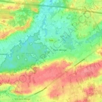
Name: Tielt topographic map, elevation, terrain.
Location: Tielt, Tielt-Winge, Leuven, Vlaams-Brabant, België (50.90607 4.87803 50.96323 4.95183)
Average elevation: 161 ft
Minimum elevation: 52 ft
Maximum elevation: 282 ft
Make a donation
Gear up for your next adventure:
As an Amazon Associate, this site earns from qualifying purchases at no extra cost to you.
Other topographic maps
Click on a map to view its topography, its elevation and its terrain.