Geolocate

Remnatsried topographic map

Click on the map to display elevation.

About this map

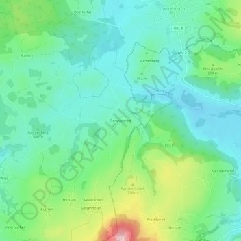
Name: Remnatsried topographic map, elevation, terrain.

Location: Remnatsried, Stötten am Auerberg, Stötten a.Auerberg (VGem), Landkreis Ostallgäu, Bayern, 87675, Deutschland (47.73526 10.71600 47.77526 10.75600)

Average elevation: 2,805 ft

Minimum elevation: 2,572 ft

Maximum elevation: 3,438 ft

Other topographic maps

Click on a map to view its topography, its elevation and its terrain.

87675

Deutschland > Bayern > Landkreis Ostallgäu > Stötten am Auerberg > Wies

Average elevation: 2,635 ft

Gear up for your next adventure:

🕶️GPS Smartphone Mount - Secure mount for phone navigation
🔭Stargazing Telescopes - Perfect for camping in low-light pollution areas shown on maps
🪶Fire Starter Kit - Reliable fire starter for survival and camping
🎁Geography Themed Gifts - Unique gift ideas for map lovers and geography enthusiasts
👟Men's Trail Runners - Lightweight footwear for fast-paced exploration and light hiking

As an Amazon Associate, this site earns from qualifying purchases at no extra cost to you.