
Make a donation
Gear up for your next adventure:
As an Amazon Associate, this site earns from qualifying purchases at no extra cost to you.
Penalva do Castelo topographic map
Click on the map to display elevation.
Make a donation
Gear up for your next adventure:
As an Amazon Associate, this site earns from qualifying purchases at no extra cost to you.
Penalva do Castelo
The toponym Penalva do Castelo originates from the Latin expression penna alba, meaning “white rock,” referring to a light-colored rocky elevation where, according to tradition, an ancient medieval fortress once stood. This fortification was located on the left bank of the Dão River, although no physical remains survive today. The mention of a "castle" in the modern name reinforces that connection to defensive structures which played an important role in the region’s surveillance and defense during the Middle Ages.
Make a donation
Gear up for your next adventure:
As an Amazon Associate, this site earns from qualifying purchases at no extra cost to you.
About this map
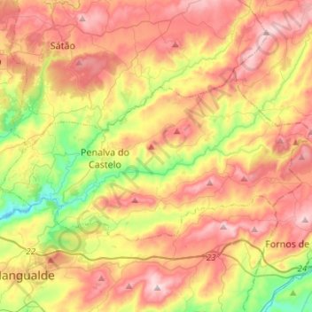
Name: Penalva do Castelo topographic map, elevation, terrain.
Location: Penalva do Castelo, Viseu, Portugal (40.62418 -7.78397 40.72648 -7.53514)
Average elevation: 1,719 ft
Minimum elevation: 935 ft
Maximum elevation: 2,493 ft
Make a donation
Gear up for your next adventure:
As an Amazon Associate, this site earns from qualifying purchases at no extra cost to you.
Other topographic maps
Click on a map to view its topography, its elevation and its terrain.
Make a donation
Gear up for your next adventure:
As an Amazon Associate, this site earns from qualifying purchases at no extra cost to you.
Make a donation
Gear up for your next adventure:
As an Amazon Associate, this site earns from qualifying purchases at no extra cost to you.
Make a donation
Gear up for your next adventure:
As an Amazon Associate, this site earns from qualifying purchases at no extra cost to you.
Casal de Cima
Portugal > Viseu > Vilar de Besteiros e Mosteiro de Fráguas > Vilar de Besteiros > Casal de Cima
Average elevation: 1,109 ft
Make a donation
Gear up for your next adventure:
As an Amazon Associate, this site earns from qualifying purchases at no extra cost to you.
Pedreles
Portugal > Viseu > Fornos de Maceira Dão > Fornos de Maceira Dão > Pedreles
Average elevation: 1,467 ft