Geolocate

Clute topographic map

Click on the map to display elevation.

About this map

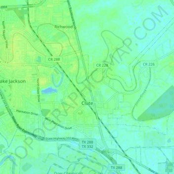
Name: Clute topographic map, elevation, terrain.

Location: Clute, Brazoria County, Texas, 77531, United States (29.00000 -95.42251 29.06246 -95.34086)

Average elevation: 16 ft

Minimum elevation: -7 ft

Maximum elevation: 36 ft

Other topographic maps

Click on a map to view its topography, its elevation and its terrain.

Rosharon

United States > Texas > Brazoria County

Average elevation: 52 ft

Damon

United States > Texas > Brazoria County

Average elevation: 82 ft

Rosharon

United States > Texas > Brazoria County

Average elevation: 52 ft

Damon Mound

United States > Texas > Brazoria County > Damon

Average elevation: 92 ft

Damon

United States > Texas > Brazoria County

Average elevation: 82 ft

Meridiana

United States > Texas > Brazoria County > Iowa Colony

Average elevation: 52 ft

Wild Peach

United States > Texas > Brazoria County > Wild Peach

Average elevation: 26 ft

Gear up for your next adventure:

🥄Camping Utensil Set - Lightweight utensils for outdoor meals
🩹Survival Bandages - High‑quality bandages for emergencies
🖼️Topo Map Wall Art - Decorative topographic prints of famous peaks and regions
🗺️NatGeo Topo Maps - High-quality waterproof printed topographic maps of US Parks
🪶Compact Camp Shovel - Folding shovel for campsite tasks

As an Amazon Associate, this site earns from qualifying purchases at no extra cost to you.