
Bodens kommun topographic map
Interactive map
Click on the map to display elevation.
About this map
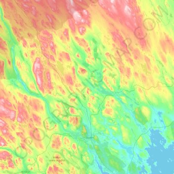
Name: Bodens kommun topographic map, elevation, terrain.
Location: Bodens kommun, Norrbottens län, Zweden (65.66329 20.36228 66.43230 22.14659)
Average elevation: 407 ft
Minimum elevation: -7 ft
Maximum elevation: 1,329 ft
Other topographic maps
Click on a map to view its topography, its elevation and its terrain.
Kangos
Kangos, Pajala kommun, Norrbottens län, Zweden
Average elevation: 741 ft
Haparanda kommun
Haparanda kommun, Norrbottens län, Zweden
Average elevation: 72 ft