Geolocate

Rioja topographic map

Click on the map to display elevation.

About this map

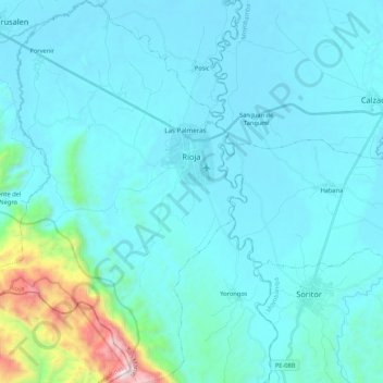
Name: Rioja topographic map, elevation, terrain.

Location: Rioja, Province of Rioja, San Martín, Peru (-6.18853 -77.28793 -5.97649 -77.13675)

Average elevation: 3,343 ft

Minimum elevation: 2,625 ft

Maximum elevation: 7,671 ft

Other topographic maps

Click on a map to view its topography, its elevation and its terrain.

Morro de Calzada

Peru > San Martín > Calzada > Calzada

Average elevation: 3,153 ft

Rey del Valle

Peru > San Martín > Alonso de Alvarado

Average elevation: 3,927 ft

Guantanamo

Peru > San Martín

Average elevation: 1,834 ft

San Andrés

Peru > San Martín > Jepelacio

Average elevation: 4,183 ft

La Unión

Peru > San Martín > La Banda de Shilcayo

Average elevation: 1,407 ft

Gear up for your next adventure:

🛰️Handheld GPS Units - Professional satellite navigators for precise backcountry mapping
🛰️Satellite Messengers - Emergency SOS and two-way messaging for off-grid adventures
📚Navigation Handbooks - Master the art of reading topographic maps and using a compass
🪶Wildlife Field Guides - Learn animal tracking and species ID
🔭Stargazing Telescopes - Perfect for camping in low-light pollution areas shown on maps

As an Amazon Associate, this site earns from qualifying purchases at no extra cost to you.