Geolocate

Java topographic map

Click on the map to display elevation.

About this map

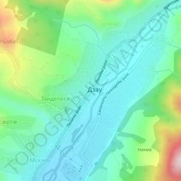
Name: Java topographic map, elevation, terrain.

Location: Java, Dzau District, South Ossetia, Georgia (42.37850 43.91401 42.40186 43.93739)

Average elevation: 3,766 ft

Minimum elevation: 3,409 ft

Maximum elevation: 4,800 ft

Gear up for your next adventure:

📦Gear Storage Bags - Organize and protect outdoor equipment
🥾Hiking Shoes - Durable and comfortable shoes for trail hiking
🌎3D Topographic Globes - Raised relief globes for a tactile understanding of geography
👟Men's Trail Runners - Lightweight footwear for fast-paced exploration and light hiking
🗃️Trail First Aid Kit - Essential kit for outdoor injuries and emergencies

As an Amazon Associate, this site earns from qualifying purchases at no extra cost to you.