
Make a donation
Gear up for your next adventure:
As an Amazon Associate, this site earns from qualifying purchases at no extra cost to you.
Gasabo District topographic map
Click on the map to display elevation.
Make a donation
Gear up for your next adventure:
As an Amazon Associate, this site earns from qualifying purchases at no extra cost to you.
Gasabo District
This district is characterized by the mixture of high mountains with average altitude of 1,800 metres (5,900 ft) mainly located in the rural zone, sloping basins and valleys. It has over 30 wetlands and small rivers traversing through the valleys. The main unique long river of about 50 km (31 mi) long and 1,000 metres (3,300 ft) wide is the one that originates from Lake Muhazi and traverses through marshy and boggy valleys before emptying into the Nyabugogo River and thereafter connects to the Nyabarongo River. Also, Lake Muhanzi in the north and part in the east borders Gasabo district. Similarly, other water sources of importance are: Rusumo River in Rugende which ends in Akagera River, Buliza River that traverses through Karuruma, Umulindi and Rusine centers before empting into Nyabugogo River. These marshlands or wetlands provide potentialities to the district if well reclaimed can enhance or increase agriculture productivity, improve tourism, improve environmental ecological system as well.
Make a donation
Gear up for your next adventure:
As an Amazon Associate, this site earns from qualifying purchases at no extra cost to you.
About this map
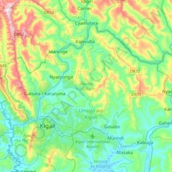
Name: Gasabo District topographic map, elevation, terrain.
Location: Gasabo District, Kigali City, Rwanda (-1.98880 29.98926 -1.77958 30.27987)
Average elevation: 5,164 ft
Minimum elevation: 4,383 ft
Maximum elevation: 7,303 ft
Make a donation
Gear up for your next adventure:
As an Amazon Associate, this site earns from qualifying purchases at no extra cost to you.
Other topographic maps
Click on a map to view its topography, its elevation and its terrain.
Kigali
Rwanda > Kigali City > Nyarugenge District
Kigali is located in the centre of Rwanda, at 1°57′S 30°4′E. Like the rest of Rwanda it uses Central Africa Time, and is two hours ahead of Coordinated Universal Time (UTC+02:00) throughout the year. The city is coterminous with the province of Kigali, one of the five provinces of Rwanda introduced in…
Average elevation: 5,020 ft
Make a donation
Gear up for your next adventure:
As an Amazon Associate, this site earns from qualifying purchases at no extra cost to you.