
Make a donation
Gear up for your next adventure:
As an Amazon Associate, this site earns from qualifying purchases at no extra cost to you.
La Grange du Pin topographic map
Click on the map to display elevation.
Make a donation
Gear up for your next adventure:
As an Amazon Associate, this site earns from qualifying purchases at no extra cost to you.
About this map
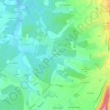
Name: La Grange du Pin topographic map, elevation, terrain.
Average elevation: 863 ft
Minimum elevation: 712 ft
Maximum elevation: 1,302 ft
Make a donation
Gear up for your next adventure:
As an Amazon Associate, this site earns from qualifying purchases at no extra cost to you.
Other topographic maps
Click on a map to view its topography, its elevation and its terrain.
Cuisiat
France > Auvergne-Rhône-Alpes > Ain > Val-Revermont
Treffort-Cuisiat fait partie du Revermont. Située au pied de nombreuses collines comme le mont Myon ou encore le mont Grillerin, elle est située à une altitude d'environ 300 mètres en plaine et culmine à 600 mètres.
Average elevation: 1,138 ft
Treffort-Cuisiat
France > Auvergne-Rhône-Alpes > Ain > Val-Revermont
Treffort-Cuisiat fait partie du Revermont. Située au pied de nombreuses collines comme le mont Myon ou encore le mont Grillerin, elle est située à une altitude d'environ 300 mètres en plaine et culmine à 600 mètres.
Average elevation: 1,050 ft
Make a donation
Gear up for your next adventure:
As an Amazon Associate, this site earns from qualifying purchases at no extra cost to you.