
Hadlow topographic map
Click on the map to display elevation.
About this map
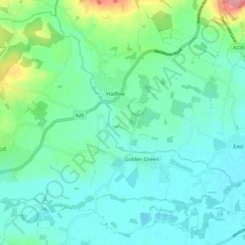
Name: Hadlow topographic map, elevation, terrain.
Location: Hadlow, Tonbridge and Malling, Kent, England, United Kingdom (51.19279 0.27974 51.24404 0.36789)
Average elevation: 98 ft
Minimum elevation: 36 ft
Maximum elevation: 341 ft
Other topographic maps
Click on a map to view its topography, its elevation and its terrain.
Ightham Common
United Kingdom > England > Kent > Tonbridge and Malling > Ightham
Average elevation: 476 ft
Barden Lake
United Kingdom > England > Kent > Tonbridge and Malling > Tonbridge
Average elevation: 108 ft
Kit's Coty
United Kingdom > England > Kent > Tonbridge and Malling > Bluebell Hill
Average elevation: 335 ft
Holborough Lakes
United Kingdom > England > Kent > Tonbridge and Malling > Snodland
Average elevation: 105 ft
Beltring
United Kingdom > England > Kent > Tonbridge and Malling > East Peckham
Average elevation: 49 ft
Pratling Street
United Kingdom > England > Kent > Tonbridge and Malling > Aylesford > Pratling Street
Average elevation: 161 ft
Royal British Legion Village
United Kingdom > England > Kent > Tonbridge and Malling
Average elevation: 108 ft
Bradbourne
United Kingdom > England > Kent > Tonbridge and Malling > East Malling
Average elevation: 92 ft