Geolocate

Bislig topographic map

Click on the map to display elevation.

About this map

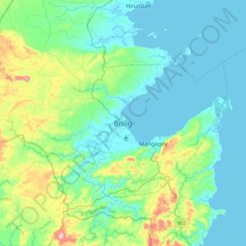
Name: Bislig topographic map, elevation, terrain.

Location: Bislig, Surigao del Sur, Caraga, 8311, Philippines (8.06059 126.15683 8.38059 126.47683)

Average elevation: 217 ft

Minimum elevation: -3 ft

Maximum elevation: 1,142 ft

Gear up for your next adventure:

🔥Fast-Boil Camping Stoves - Efficient cooking systems for quick trail meals
🏔️Mountain Trail Maps - High‑detail maps for popular peaks
🧭Outdoor Navigation Book - Learn advanced navigation skills
🦶Carbon Trekking Poles - Reduce knee impact on steep descents with ultra-light poles
📚Navigation Handbooks - Master the art of reading topographic maps and using a compass

As an Amazon Associate, this site earns from qualifying purchases at no extra cost to you.