Geolocate

Leander topographic map

Click on the map to display elevation.

About this map

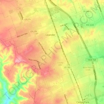
Name: Leander topographic map, elevation, terrain.

Location: Leander, Williamson County, Texas, United States (30.52031 -97.89537 30.60031 -97.81537)

Average elevation: 997 ft

Minimum elevation: 774 ft

Maximum elevation: 1,161 ft

Williamson County trails, hiking, mountain biking, running and outdoor activities

Gear up for your next adventure:

🚑Emergency Bivvies - Heat-reflective sleeping bags for survival situations
🧦Hiking Socks - Comfortable socks to prevent blisters on long hikes
🦟Ultrasonic Repellers - Create a bug-free zone at your camp or rest stop
Backpacking Tents - Weight-optimized shelters for multi-day topographic surveys
🥾Men's Hiking Boots - Durable, waterproof footwear for rugged terrain and steep inclines

As an Amazon Associate, this site earns from qualifying purchases at no extra cost to you.