Geolocate

Schauenstein topographic map

Click on the map to display elevation.

About this map

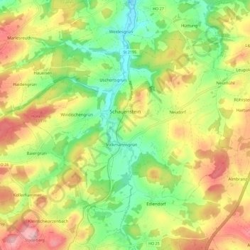
Name: Schauenstein topographic map, elevation, terrain.

Location: Schauenstein, Landkreis Hof, Bavaria, 95197, Germany (50.24865 11.67794 50.29880 11.79024)

Average elevation: 1,946 ft

Minimum elevation: 1,670 ft

Maximum elevation: 2,280 ft

Gear up for your next adventure:

🛠️Outdoor Gear Repair Kit - Essential tools to fix gear on the trail
🏕️Family Camping Gear - Essentials for group camping trips
👟Trail Running Shoes - Lightweight shoes for trail runners
🧭Map Reading Tools - Tools and kits for map navigation
🧢Outdoor Hiking Hat - Sun protection hat for outdoor explorers

As an Amazon Associate, this site earns from qualifying purchases at no extra cost to you.